Gravel
AragatsotnFortress
Shirak — At Armenia's western edge, a few hundred metres from the sealed border river Akhurian, stand the remains of one of the country's oldest Christian basilicas: Yereruyk, carved from orange-red tuff, resting silently on a six-stepped stylobate – and abandoned to decay for centuries.
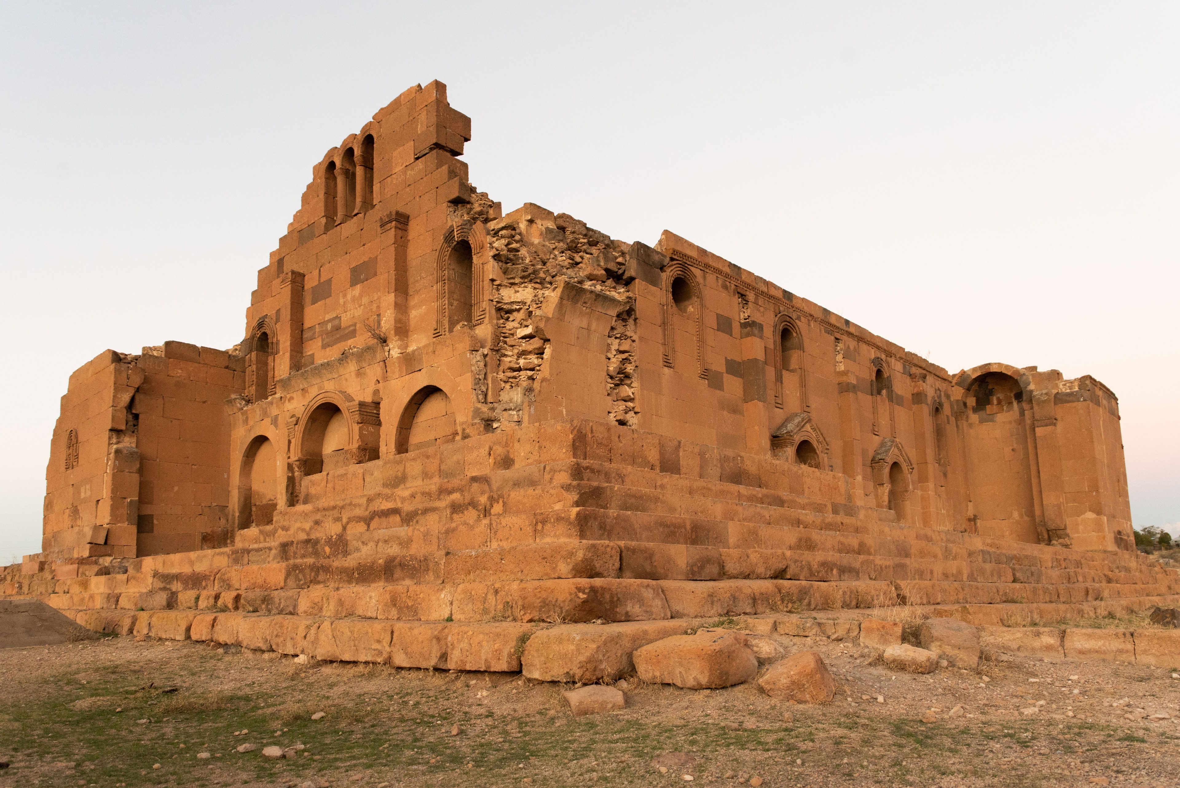
Yereruyk is said to mean "the trembling one": seen from a distance, the ruin is said to float on its six columns, swaying gently in the wind. Around it spreads a graveyard of finely carved stone pedestals: adult graves, possibly plague victims, lie beside infant graves that, according to tradition, were buried in the shadow of the shrine to the Forerunner. A Greek inscription on the façade quotes a psalm, with a direct parallel found in a monastery far away in Syria. Across the river, you can make out the outline of a lost city.
The ruins of Yereruyk Basilica lie on a gently elevated plateau near the village of Anipemza in Shirak region, at 1,430 metres above sea level. Directly across, beyond the Akhurian River on the Turkish side, the ruins of the medieval capital Ani are visible – one of the few places where Armenia and Turkey lie so close. The structure is a three-aisled basilica of red tuff stone, quarried from the same pits as those in neighbouring Ani. Thick side walls, columned halls on three sides, two apsidal chapels, prominent corner towers to the west – the underlying form remains legible despite damage. The ground around the ruin holds an extensive cemetery with elaborately worked stone pedestals; excavations uncovered adult and infant burials, possibly victims of plague epidemics. The basilica has been on UNESCO's tentative list since 1995 as one of Armenia's earliest surviving Christian monuments.
Offroad & access
Offroad factor: 2 out of 5 – access is passable for regular vehicles but demands attention. From Anipemza, paved village roads and then unmade gravel and farm tracks lead to the basilica. The route is short (under 3 km from village centre), tracks wide enough for an SUV. In dry conditions a 2WD vehicle with adequate ground clearance suffices; after rainfall the clayey sections may become slippery, a 4x4 then provides much greater reserve. Major potholes or fords are not expected. The elevation of 1,430 m means year-round accessibility; in winter snow may temporarily block the final sections. Parking available on-site but unpaved. The real distinctiveness of the approach lies not in terrain difficulty but in setting: left, the Akhurian as boundary line; right, open Shirak highlands; ahead, the tuff-stone remnant – with no visual corridor crowded by other visitors.
Building type: Three-aisled early Christian basilica, western type with broader central nave. Building phases: began 4th century, interrupted 5th century, completed 6th century – exact dates hypothetical due to absence of contemporary written sources. Renovation in 11th century under the wife of King Hovhannes-Smbat documented. Material: Orange-red tuff stone from the quarries of the city of Ani. Dimensions: Original height approximately 30 metres; foundation directly on bedrock, no continuous substructure. Decoration: Bas-relief ornament with Maltese cross motifs, animal and tree representations on architrave and capitals; Greek inscription on southeast facade (parallel to Syrian churches of 5th century). Dedication: Martyrial sanctuary, inscription on northeast pilaster names 'Martyrion of the Forerunner and of the Proto-Martyr' – John the Baptist and Stephen the Proto-Martyr. Location: 40.4397° N, 43.6092° E, Shirak, Armenia; approximately 5 km southeast of Ani (Turkey). UNESCO Tentative List: registered 25 August 1995. Earthquake impact: The 1988 earthquake (Spitak quake, magnitude 6.8) caused further structural damage; roof had already collapsed by 17th century. Ongoing restoration: In 2023 the US Embassy approved a grant of USD 175,000 for wall stabilisation, stone repair and drainage system.
Armenia adopted Christianity as state religion in 301 CE, the world's first nation to do so. Yereruyk arose in this early Christian expansion: construction began likely in the 4th century, finished in the 6th, making the basilica among the oldest surviving churches in the country. Its architectural features – three-aisled plan, columned halls, Hellenistic-influenced dentil moulding – point to close ties with Syrian early Christian architecture. The Greek inscription on the southeast facade, drawn from a psalm ('Holiness adorns thy house, O Lord, for ever'), finds a direct parallel in the Syrian Deir Sem'an monastery from the late 5th century. Armenian archaeologist Toros Toramanian documented the building at the end of the 19th century as an early example of the Armenian basilical type on pillars. In the 11th century the wife of King Hovhannes-Smbat had the church renovated – when neighbouring Ani, as capital of the Bagratid kingdom, experienced its peak. The roof collapsed by the 17th century at latest; the 1988 earthquake further damaged the masonry. Today a US conservation programme safeguards the remaining fabric.
According to tradition, the name Yereruyk derives from the Armenian word for 'trembling' or 'swaying'. Those viewing the ruin from a distance are said to perceive the building not standing firmly on the ground but hovering on its six columns, swaying slightly in the wind – an optical illusion created by the open support system interacting with highland light. A second, unwritten tradition links the church to veneration of John the Baptist: because the shrine served as a martyrial sanctuary of the Forerunner, families were said to bury unbaptised children preferentially in its shadow – a practice archaeologically reflected in the numerous infant graves across the church grounds, though direct causation remains uncertain.
Yereruyk occupies a location most Armenian travellers never see: the western border zone, where the Akhurian forms the frontier with Turkey and ancient Ani lies visibly across on the other bank. The building itself is no pristine postcard monument but an honest ruin – tuff walls, open sky instead of roof, grass among foundations, wind. Those wishing to experience early Christian architecture without tourism infrastructure, with awareness of standing at one of the region's longest and most complex borders, find here a place operating on multiple levels at once: historical, geopolitical, atmospheric.
Access: From Gyumri (Armenia's second-largest city) approximately 35–40 km westward toward Anipemza, final kilometres over gravel roads. GPS coordinates: 40.4397° N, 43.6092° E. Season: April to November recommended; summer hot and dry, spring and autumn more pleasant. Entry: No formal admission, grounds publicly accessible. Border zone: Area lies immediately at Armenia-Turkey frontier; the Akhurian border river is sealed – no crossing possible. Observe local authority safety guidelines. Combination: Well linked with a visit to Gyumri (approximately 50 km east) or the former capital Ani (on Turkish side, separately accessible via Kars). No dining or lodging directly on-site; bring provisions from Gyumri or Artik.
AragatsotnFortress
AragatsotnLake
AragatsotnMountain
To experience early Christian history of Armenia at a place neither musealised nor overrun, Armenia Expeditions arranges access to Yereruyk as part of a tailored Shirak programme for you. One message — we’ll plan the rest.