Gravel
ShirakArchaeology
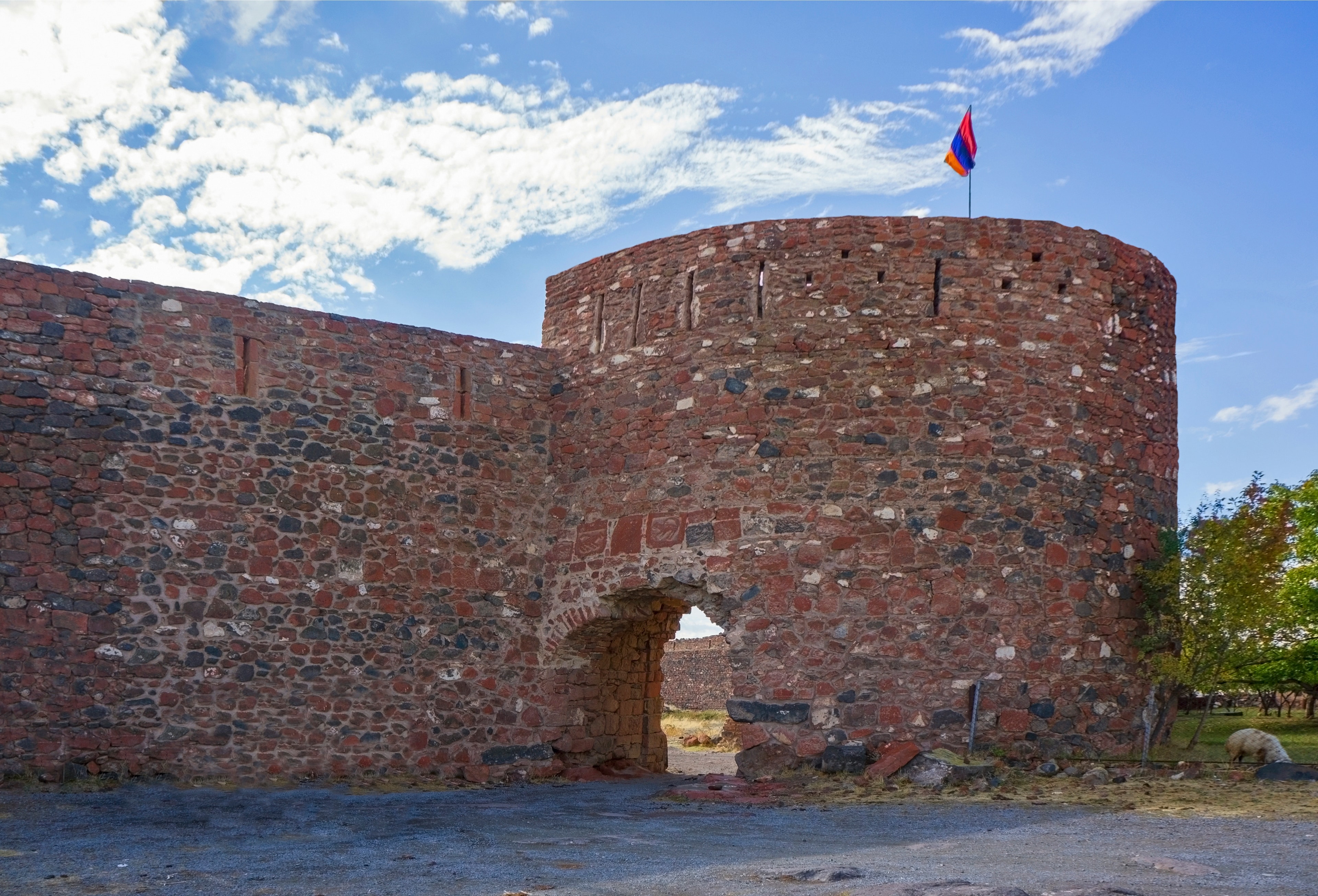
Aragatsotn — On the Talin plateau rises an octagonal wall ring from the 19th century atop a core dating to the 9th century. What appears from afar as a compact military work reveals itself as Armenia's overlapping construction history rendered in miniature.
Beneath your feet run chambers and passages still not fully mapped — legend says a tunnel leads from here all the way to Ani, a good fifty kilometres away as the crow flies. Archaeologists consider that embellishment; the tunnel itself is unproven. Above the main gate, two lions watch in flat relief, and a 14th-century Armenian inscription records, of all things, a wine-tax exemption for the village of Talin.
Dashtadem fortress stands at the southern edge of the village of the same name in Aragatsotn Province, on a flat plateau of the Talin Plain, roughly 1,458 meters above sea level. The Armenian name means roughly 'opposite the field'—a spare topographic description befitting the site's character. The structure once secured the eastern access routes to the medieval metropolis of Ani, controlling one of the most vital corridors between the Armenian highlands and the plains toward what is now Turkish territory.
Offroad & access
Offroad factor 2 out of 5. Access to Dashtadem runs via the main road toward Talin, then along a well-maintained gravel and field track directly to the village edge. In dry conditions the route is easily passable in a standard 4WD or high-clearance 2WD vehicle. In winter the track may soften briefly after precipitation, but remains generally accessible year-round owing to its modest elevation of 1,460 meters on a low-lying plateau—snow cover rarely persists long. Parking directly at the base of the outer wall; the fortress is accessible on foot. Solid footwear is advisable for inspection of the ramparts and outer towers; some inner wall sections lack railings.
The fortress complex comprises three superimposed construction phases. The oldest surviving core—a rectangular donjon with attached half-towers—dates to the 9th–10th century, erected during the Bagratid dynasty. Beneath it lie foundation and wall fragments pointing to earlier use, possibly into the Urartian period. The second layer stems from 1174: an Arabic inscription in Kufic script on the donjon's east wall names Sultan ibn Mahmud ibn Shavur, a Shaddadid prince from Ani, as the builder of polygonal and semicircular towers. Within months of completion, Shaddadid rule ended—Georgian forces took the territory. In the Zakariad period of the 12th–13th centuries, an inner ring wall and a church of red tuff, dedicated to Saint Sarkis, were added. The third and outermost wall ring—an nearly circular polygon with eight corner towers and walls up to eight meters thick—was built in 1812 at the behest of Huseyn Khan, the Sardar of Erewan. Excavations in 1989, 2005–2006, 2011–2012 (French expedition), and 2015 yielded ceramics, bronze vessels, sword blades, glass bracelets, a 12th-century Seljuk copper coin, and a 13th-century mason's inscription by a builder named Hovhannes. Underground cisterns and a water reservoir cut into the rock ensured supply during sieges. Above the main gate, two lions are depicted in low relief.
The earliest documented rule belonged to the Kamsarakans, an Armenian noble house with roots in the 4th century, who governed the Shirak region. The present donjon arose in the Bagratid period, when the fortress secured the realm's eastern flank and supply routes to the capital Ani. In 1174, the Shaddadid prince Sultan ibn Mahmud added new towers—a fact attested by the still-extant Kufic Arabic inscription, one of the few Islamic architectural records on Armenian soil from that era. The Zakariads, a Georgian-Armenian dynasty, took the complex shortly thereafter and reinforced it with an inner ring wall and church construction. Following Mongol devastations, whose traces appear as burn layers in the second upper story, the fortress changed hands repeatedly. A 14th-century Armenian inscription records a wine-tax exemption for Talin—an unusual civil document within a military fortification. The final major renovation in 1812 was financed by Huseyn Khan of Erewan, who raised the polygon wall in response to geopolitical upheaval following Russo-Persian conflicts.
According to tradition, an underground tunnel connects Dashtadem fortress to the medieval city of Ani—roughly 50 kilometers distant as the crow flies, now on Turkish soil. The legend stems from the actual subterranean chambers and galleries within the fortress, whose full extent has not yet been completely mapped. No archaeological evidence for such a long tunnel exists; excavators regard the story as a popular embellishment of the real tunnel structure. The Church of Saint Sarkis within the walls is linked in Armenian tradition to the martyr saint and warrior-patron venerated as protector of lovers—a connection not further documented within the fortress itself.
Dashtadem is among the few Armenian fortresses where four distinct epochs of rule are architecturally legible: Bagratids, Shaddadids, Zakariads, and Qajar Persians all left marks still visible side by side. The 1174 Kufic inscription stands as one of the earliest dated Islamic architectural records on Armenian soil. The complex sees little tourist flow and minimal interpretation—visitors examine the walls without admission fees, guided requirements, or barriers around the inscriptions.
Admission: free, no fixed hours. Accessible year-round. Best light for photography in the morning (east wall with Kufic inscription receives morning sun). Nearest supplies in Talin, approximately 10 km away. Immediately south of the fortress, about 1.7 km distant, stands the restored Kristapori Monastery from the 7th century (Kristapori Vank)—worthwhile for combined visit. Coordinates: 40.338393° N, 43.856902° E.
ShirakArchaeology
AragatsotnLake
AragatsotnFortress
Would you like to visit Dashtadem as part of a guided exploration of Aragatsotn? Armenia Expeditions explains the fortress on-site—dynasties, inscriptions, construction phases—and combines the stop with other regional destinations. One message — we’ll plan the rest.